Six storey love song

Georges-Eugène Haussmann’s urban renewal programme in Paris in the 1800s saw the rise of distinctive wide boulevards lined with uniform six-storey buildings.
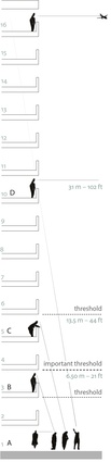
Sight thresholds are outlined by Danish architect and urban designer Jan Gehl in Cities for People.
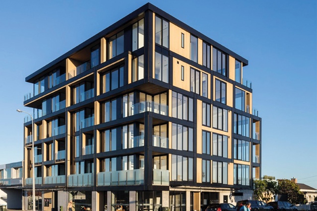
Six-storey apartments on Auckland’s Great North Road.

Haussmann’s ubiquitous six-storey apartment buildings in Paris.
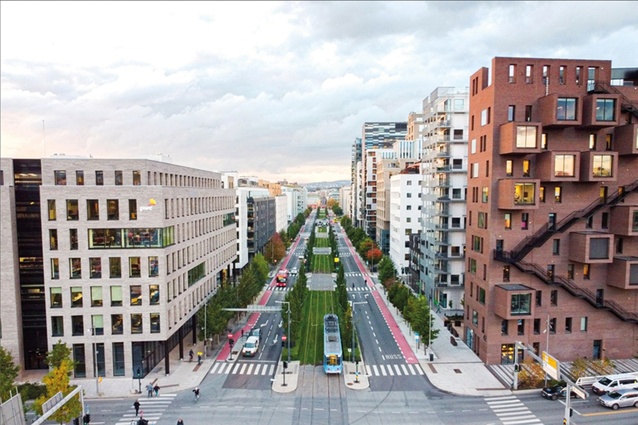
The Oslo Bjørvika tramway in Norway is lined with a slightly denser, sustainability-focused variation on the Haussmann concept.

In suburbs such as Wellington’s Mount Victoria, low-density zoning and special character rules are applied in district plans to manage change in built form and character.
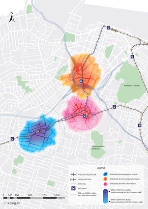
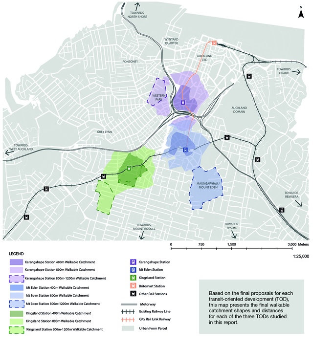
Third-year Urban Planning student Katsuki Kurimasa’s walkable catchment map shows walking areas limited to within the 800m radii, taking into account street networks and other factors.
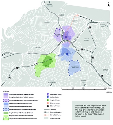
This map, by third-year Urban Planning student Oudom Yat, shows discrete segments of each catchment extending to 1200m, to account for favourable amenity and proposed streetscape improvements. Yat supports this by referencing some of the literature that suggests that a distance of up to 1200m can be considered walkable in certain instances.
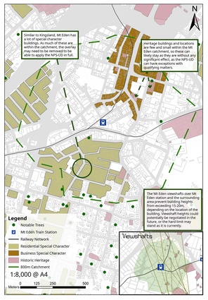
Bennet Atkins’ built form constraints map within his walkable catchment for Mount Eden station illustrates the large area of land subject to a special character overlay. Atkins is a third-year Urban Planning student.
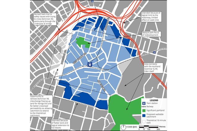
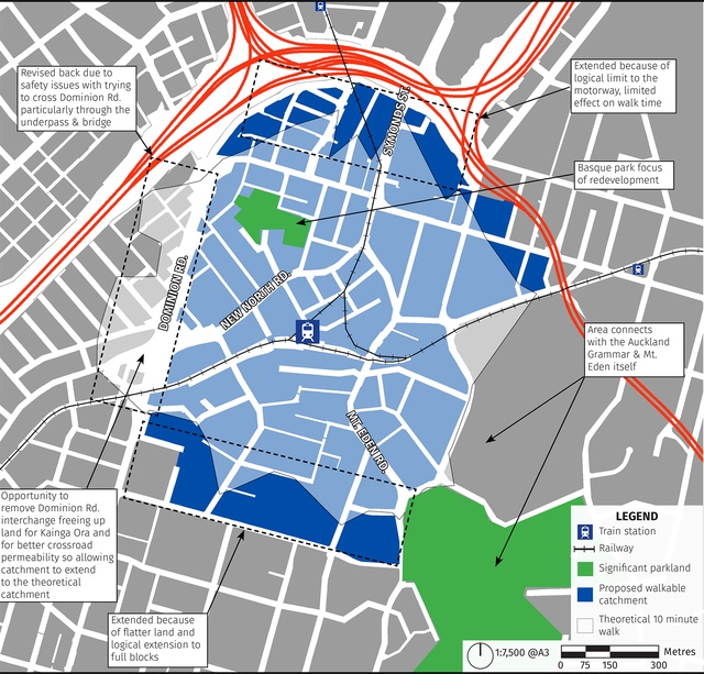
Pero Garlick’s Walkable Catchment map of the Mount Eden Station highlights how Dominion Road and its interchange present many challenges, including what Garlick describes as “unsafe underpasses and bridges” on the direct route to the station. He recommends that it could be reconfigured to offer a safer crossing, extending the catchment beyond the road.
Matthew Paetz grapples with new density controls in the National Policy Statement on Urban Development 2020 (NPS-UD), perhaps the most significant government policy for cities in Aotearoa New Zealand of the past 30 years.
The National Policy Statement On Urban Development (NPS-UD) contains a lot of policy wonkery but its big-ticket item is its mandate for our bigger cities that enables high-density development near train stations, CBDs and commercial centres. This mandate means councils in Auckland, Hamilton, Tauranga, Wellington and Christchurch must rezone land in these locations with maximum building height rules of six storeys (or higher, if councils choose).1
It’s not clear when reading the NPS-UD and supporting documentation as to the basis for six storeys. Background reports mention a range of benefits of concentrating density in areas of high demand and near centres and public transport.
I’ve heard it said that six storeys is the maximum building height for retaining human scale; however, this misconstrues what human scale is. If we turn to the literature, then four or possibly five storeys are considered the upper limit for a building size that is not overly dominant (at least in residential areas and urban villages), and within which a reasonable relationship between people in buildings and those on the street can be attained.2
Another good reason to promote density near train stations is to support public transport and reduce reliance on car transport, and the NPS-UD alludes to this. There is a large amount of literature on this topic and there is a well-established link between density and transport; however, international authorities on this subject matter, including Robert Cervero and Reid Ewing, show that there is not a linear relationship between density and public transport outcomes. Cervero et al. argue that the biggest benefits occur when urban form changes from low-density suburbia to low-rise, medium-density housing (two and three-storey ‘walk-up’ townhouses and apartments).3
The government may have missed a trick here: six-storey development is likely to be realised by the market only sporadically. The NPS-UD’s mandates set unrealistic expectations and might also prove to present a rather unnecessary public relations nightmare once plan changes are actioned. Further, high densities can be achieved with four-storey development, at a scale much more compatible with suburban settings.
The NPS-UD demands that this rezoning should occur within walkable catchments of train and bus stations on rapid transit corridors and in CBDs and metropolitan centres.4 Interestingly, areas served by ferries are not included in this requirement – the frequency and capacity of ferry services are not sufficient to qualify them as ‘rapid transit services’. Notwithstanding this, there are guidelines in the NPS-UD that suggest councils might still consider higher densities around settlements served by ferries.

In the urban planning discipline, a walkable distance is typically considered to be between 400 and 800 metres (with a tendency towards the latter). For many, this usually equates to a five-to-10-minute walk. To arrive at a crude walkable catchment, a radius of either 400m or 800m is applied, as the crow flies, from a train station or urban centre.
However, on the ground, a range of constraints impacts on walkability. A nuanced assessment of walkability should consider topography and the presence, or otherwise, of major walking barriers, such as motorways, as well as factors such as personal safety and the amenity and visual interest of a walking route.
To bring this concept alive, students participating in my third-year Urban Planning course at the University of Auckland assessed and mapped the walkable catchments of three stations on the City Rail Link (CRL) line currently under construction.
In the students’ work, there is effectively one large, contiguous urban area where six-storey redevelopment is enabled (with a few exceptions). Remember, this is based on the framework set by the NPS-UD – not on sound urban planning principles.
In a future assignment, the students will select one of the three urban centres and create an urban plan based on the NPS-UD’s parameters. Following this, they will critique the plan and outline what their approach would have been without the NPS-UD’s straitjackets, and while applying the skills of true contextual urban planning that considers a range of factors in determining appropriate zoning and built form scale.
As an urbanist, I support the spirit (if not all the detail) underpinning many of the NPS-UD’s mandates. We need bolder urban planning and development to help support our goals of realising more compact cities in order to address two key crises before us – housing and climate change. Our bigger cities have not been bold enough on density, although, to be fair, the political economy of urban densification can be very challenging; this provides important context for why the government has imposed the top-down approach of the NPS-UD.
Zone and they will come?
Six-storey built form can work well in dense urban cores or on wide arterial roads. In Auckland, Terrace Housing and Apartment Building (‘THAB’) or Mixed Use zoning often fronts wide arterial routes such as Great North Road. In this setting, this scale of building is more proportionate to the scale of the street and the public realm. Arterials are also the locations for good public transit routes, or have the potential to become so, offering compelling settings for mid-rise urban intensification.
The most obvious historic precedent is provided by the Haussmann apartments of Paris from the mid-1800s; typically, each block of apartments is six storeys in height with a 45-degree sloped mansard roof. However, these were a very considered, planned and comprehensive urban response. Katy Chey states that, with a blank canvas for urban renewal and upon instruction from no less than Napoléon III, “Haussmann saw the street block holistically and as an entire architectural body”.5 This avoided ad hoc urban outcomes and a central aspect of the success of Haussmann’s apartments was that building scale related well to street width and design – wide boulevards that were well planted with large street trees.

In more recent times, Oslo (a city whose population is similar to that of Auckland) in Norway has applied a slightly denser, sustainability focused variation on the Haussmann concept in its central urban areas.
So, this scale of development can work brilliantly in the right settings, when it is well coordinated, planned and designed. However, six storeys can be jarring and out of scale in suburban contexts where comprehensive urban development is not possible. The NPS-UD should have mandated four storeys and directed higher-scale development to arterial road frontages and in immediate proximity to train stations and centres – a more nuanced and contextual approach.
Even if planning rules enable six-storey buildings, redevelopment is likely to be incremental and inconsistent in scale and usually much lower than this maximum. We have seen with the THAB zone in Auckland that it isn’t always ‘zone and they will come’. Much of the development occurring in the THAB zone has been of medium density – often two to three storeys, despite the zone enabling development of at least five storeys.
Rules like height in relation to boundary make it hard to achieve development of a scale higher than three or four storeys on typical suburban sections. The NPS-UD alludes to the need for removing or heavily liberalising height in relation to boundary rules, and this will help.
However, economic factors are perhaps even more important. The cost of construction increases significantly once development is higher than three storeys. Much more capital is required to fund larger developments – why bother when you can whack up a bunch of two or three-storey townhouses and make a good buck? Bigger isn’t always better. We need to distinguish between ‘highest and best use’ – which may be a five or six-storey apartment building offering the greatest profitability – and ‘most probable use’: a development option far less ambitious but still offering good profitability and requiring significantly less capital (and involving less risk).
In most locations – apart, perhaps, from areas with very high land values – developers typically work well within four storeys. The government is likely to find that its vision of widespread six-storey redevelopment fails to eventuate – not because planning rules are too restrictive but because of economic factors. This is a weakness of the NPS-UD and its neo-liberal philosophical underpinnings, which assume that regulation is the main obstacle to high-density housing supply.
In Auckland, the implications of the intensification mandate may not be so significant – with the notable exception, perhaps, of areas with ‘special character’ rules (see below). This is because many areas in Auckland are already zoned for medium density of two to three storeys under the Auckland Unitary Plan – a ‘sweet spot’ for redevelopment. In Wellington, with the city’s new District Plan due, the NPS-UD is likely to make the plan much bolder on density than it might have been otherwise.
Hamilton, Tauranga and Christchurch will also need to make significant changes to their District Plans. With limited rapid transit service, the high-density zoning will be focused mostly on areas close to their main commercial centres. Again, the rezoning may provide the potential for six-storey apartment buildings but development is likely to occur mainly as low-rise, medium-density typologies.
Critically, design will become more important than ever. In particular, there will need to be emphasis on human scale in design. Architects and urban designers have key roles to play.

What about the Special Ones?
Another big question relates to areas identified as having ‘special character’ (basically, areas with consistently high levels of old housing) in district plans. In Auckland’s central suburbs, such as Ponsonby and Mount Eden, or Wellington’s Mount Victoria, low-density zoning and special character rules are applied in plans to manage change in built form and character. Despite their benefits, these quite restrictive rules hinder redevelopment of centrally located areas which, in a spatial sense, are well suited to higher-density development – close to CBDs, public transport and employment.
The NPS-UD does provide a potential ‘out’ for councils in terms of the requirement to rezone land for high-density development in these settings. That ‘out’ is what the NPS-UD calls ‘qualifying matters’. The most obvious example of a qualifying matter is a building or precinct with heritage protection.

Technically, areas subject to special character rules might be eligible for exemption from high-density rezoning. However, a key factor is that the NPS-UD demands a high level of objective evidence on a site-by-site basis in order to exempt intensification requirements. This might make blanket regulations, as applied in special character areas, difficult for councils to justify.
Even if there is a good case to avoid six-storey building height limits in these areas, the NPS-UD demands more than simply sticking with the status quo. At the very least, we should expect rezoning in these areas that allows for medium-density development of three storeys. It may be appropriate to retain controls on built form and materials to help ensure redevelopment is sympathetic to special character.
Don’t forget parking
Another key policy in the NPS-UD is its mandate for councils to remove minimum parking requirements for development from district plans. There are two key foundations for this.
Firstly, why mandate onsite parking when people may not need or want it? While still
in the minority, an increasing number of New Zealanders do not own private motor vehicles, and levels of car licence-holding among younger people is decreasing. Car-share schemes, while in their infancy, have potential to grow significantly.
Secondly, the concept of banning minimum carparking requirements in district plans is coupled with the pro-intensification agenda of the NPS-UD, and its focus on dense urban development evolving to offer better support for good public transport services (and vice versa – there is a bidirectional relationship at play).
The NPS-UD’s banning of minimum carparking rules applies everywhere, even in low-density suburban areas remote from good public transport services. Parking management strategies are likely to play a critical role in addressing the challenges that will come with this policy.
Top-down versus collaborative planning
Finally, a big philosophical question concerns the ‘top-down’ approach to urban planning that the NPS-UD employs. High-density rezoning is effectively imposed on communities from above by central government, with limited potential for exemptions. Although councils must publicly notify plan changes to deliver on the NPS-UD’s requirements, there will be limited scope for individuals and communities to influence final decisions through submissions.
Some will argue that this mandate is necessary to enact the urgent change necessary to help address Aotearoa New Zealand’s arguably two most pressing issues – housing and climate change. I fall into that camp but with the caveats outlined. Others will say that the NPS-UD fundamentally undermines local decision-making and democracy and the art of urban planning, which considers these perspectives as well as environmental and contextual considerations. It is certainly a valid perspective.
The NPS-UD sets out time frames for delivery of its requirements by councils. The intensification requirements need to be progressed substantially by August 2022, while the removal of parking requirements must be actioned by early 2022.
The NPS-UD creates a number of interesting challenges and opportunities for architects. It will accelerate the transition of our larger urban areas from places dominated by low-density, detached housing typologies towards townhouse and apartment typologies. Notwithstanding some concerns raised here, this will undoubtedly deliver many opportunities and benefits.
The canvas has been provided by the government. It’s now over to architects, urban designers, planners and councils to paint on it while continuously advocating for the benefits of well-designed built form and urban development – something the NPS-UD doesn’t even address.
Matthew Paetz is Professional Teaching Fellow in Urban Planning at the University of Auckland. In 2013, his work on medium-density housing policy in Adelaide received multiple awards from the Planning Institute of Australia. More recently, he led the development of the Queenstown District Plan and was an urban policy advisor at the Ministry for the Environment
1 There are some limited exceptions to this requirement.
2 Jane Jacobs advocated building scales typically of four to five storeys – refer The Death and Life of Great American Cities (1964). Christopher Alexander et al. in A Pattern Language (1977) advocated for maximum building heights of four storeys. Jan Gehl in Cities for People suggested that, above five storeys, the relationship between buildings and streets can become challenging to reconcile. Despite these ‘general rules’ on building scale, all three of these great urban thinkers made it clear that, in certain circumstances, taller buildings would be appropriate, and even desirable, depending on context.
3 Robert Cervero, Erick Guerra and Stefan Al, Beyond Mobility: Planning Cities for People and Places, Island Press, 2017.
4 The mandate is not limited to existing rapid transit corridors – if light rail is realised in the future, then the NPS-UD’s requirements will apply to it. In Auckland, one can then envision a dense, mixed-use corridor.
5 Katy Chey, Multi-Unit Housing in Urban Cities – From 1800 to Present Day, Routledge, 2017.